
Field Geologist (free)
คำอธิบายของField Geologist (free)
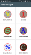
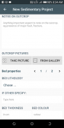
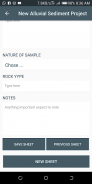
Field Geologist is an app designed to replace traditional geological field notebook. It is a degital field notebook used in recording data on igneous, metamorphic and sedimentary rocks in outcrop or core sections as well as alluvial and stream sediments during geological field mapping. Field Geologist works offline and runs on consumer grade android phones and tablets. The recorded information is grouped automatically as individual projects that can be saved either internally on the device or any external drive. The data can ultimately be exported in Excel (CSV) format, saved to device, share or transferred to a PC or other devices in a single click using any transfer media such as Bluetooth, Xender, Whatsapp etc.
X= Main Features:
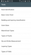
Recording field data on igneous, metamorphic and sedimentary rocks as well as alluvial and stream sediments during field geologic mapping. Also used for core logging.
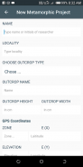
Well designed easy to use, standard data sheets (Limited acess, gain full access by purchasing full version of App).
Uses device Camera to collect and save field pictures
Field Geologist works offline and runs on consumer-grade android phones and tablets.
The recorded information is grouped automatically as separate projects that can be saved either internally to device or externally to the geologists Google drive or any other data base.
The data can ultimately be exported to CSV/Excel format and transferred to the PC or other devices in a single click.
Automatic data backup based on intervals choosen by user
X= Additional Features (available only in the new version):
Collect your GPS data directly using your phone (May require internet)
Recieve geology scholarships and job notifications
Recieve short articles on new developments in the geosciences
Field Geologist เป็นแอพที่ออกแบบมาเพื่อแทนที่โน้ตบุ๊กภาคสนามแบบดั้งเดิม มันเป็นสมุดบันทึกฟิลด์ degital ที่ใช้ในการบันทึกข้อมูลบนหินอัคนี, หินแปรและตะกอนในส่วน outcrop หรือแกนหลักรวมถึงลุ่มน้ำและตะกอนตะกอนในระหว่างการทำแผนที่ทางธรณีวิทยา นักธรณีวิทยาภาคสนามทำงานแบบออฟไลน์และทำงานบนโทรศัพท์และแท็บเล็ต Android ระดับผู้บริโภค ข้อมูลที่บันทึกไว้จะถูกจัดกลุ่มโดยอัตโนมัติเป็นแต่ละโครงการที่สามารถบันทึกได้ทั้งภายในบนอุปกรณ์หรือไดรฟ์ภายนอก ในที่สุดข้อมูลสามารถส่งออกในรูปแบบ Excel (CSV), บันทึกไปยังอุปกรณ์, แชร์หรือถ่ายโอนไปยังพีซีหรืออุปกรณ์อื่น ๆ ในคลิกเดียวโดยใช้สื่อการถ่ายโอนใด ๆ เช่น Bluetooth, Xender, Whatsapp เป็นต้น
X = คุณสมบัติหลัก:
การบันทึกข้อมูลภาคสนามเกี่ยวกับหินอัคนีหินแปรและหินตะกอนรวมทั้งตะกอนดินและลุ่มน้ำในระหว่างการทำแผนที่ธรณีวิทยาภาคสนาม ยังใช้สำหรับการบันทึกหลัก
ออกแบบมาอย่างดีแผ่นข้อมูลมาตรฐานที่ใช้งานง่าย (acess จำกัด มีสิทธิ์เข้าถึงแบบเต็มโดยการซื้อแอปเวอร์ชันเต็ม)
ใช้กล้องของอุปกรณ์เพื่อรวบรวมและบันทึกภาพในฟิลด์
นักธรณีวิทยาภาคสนามทำงานแบบออฟไลน์และทำงานบนโทรศัพท์และแท็บเล็ต Android ระดับผู้บริโภค
ข้อมูลที่บันทึกไว้จะถูกจัดกลุ่มโดยอัตโนมัติเป็นโครงการแยกต่างหากที่สามารถบันทึกได้ทั้งภายในอุปกรณ์หรือภายนอกจากนักธรณีวิทยา Google ไดรฟ์หรือฐานข้อมูลอื่น ๆ
ในที่สุดข้อมูลสามารถส่งออกไปยังรูปแบบ CSV / Excel และโอนไปยังพีซีหรืออุปกรณ์อื่น ๆ ในคลิกเดียว
สำรองข้อมูลอัตโนมัติตามช่วงเวลาที่เลือกโดยผู้ใช้
X = คุณสมบัติเพิ่มเติม (มีเฉพาะในเวอร์ชั่นใหม่):
รวบรวมข้อมูล GPS ของคุณโดยตรงโดยใช้โทรศัพท์ของคุณ (อาจต้องใช้อินเทอร์เน็ต)
รับทุนการศึกษาธรณีวิทยาและการแจ้งเตือนงาน
รับบทความสั้น ๆ เกี่ยวกับพัฒนาการใหม่ ๆ ในธรณีศาสตร์
Field Geologist (free)--เวอร์ชั่น1.05
(19-02-2021)Field Geologist (free) - ข้อมูล APK
เวอร์ชั่น APK: 1.05แพ็คเกจ: tafieldscience.fieldgeologistfreeเวอร์ชั่นล่าสุดของField Geologist (free)
เวอร์ชั่นอื่น


 3.55
3.55แอปในประเภทเดียวกัน